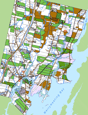
As places like Bowdoinham seek to define themselves through the comprehensive planning process, the role of their forests and natural areas will be a major consideration. The towns people have placed a high priority on the preservation of these resources, but as growth pressure mounts and the sale of the family forest or farms becomes more lucrative, these lands become threatened by fragmentation. Each of the areas in the map below in cross hatches represents lands that have been split in some way or another since 2004. Parcels in green or brown are enrolled in state land preservation programs. Those with both cross hatches and program enrollment represent land use patterns that are threatened in some way or another, whether they are agricultural or forestry oriented.
 |
| Lands Enrolled in the Maine Tree Growth (green parcels) & Open Space (brown parcels) Program, contrasted with parcels that have split since 2004 (cross hatches). |
For now, we have made the observation that Bowdoinham has experienced some parcelization and that some of those splits occur on lands that were at one time enrolled in programs designed to prevent the fragmentation of these lands. Whether they decide to work with an active land trust, or develop policies geared to restricting land use rights in Bowdoinham is up to them. Some combination of the two might be the best, working to preserve lands through transfer of development rights, restrictions of how much or how often land is split and developed, and growing the awareness of land-owners of what their land means to rural Maine way of life and how best to preserve it.
No comments:
Post a Comment